Finding the Devil
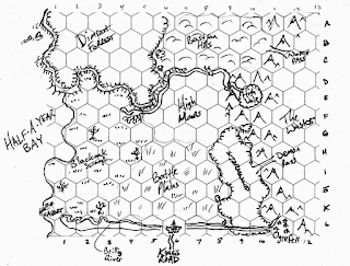
A week or so ago I posted the small scale map for my current hex-crawl campaign, The Borderwilds. A few days laterYellowDingo (over on his own blog) made a blanket offer to create a detailed hex-map in the classic style for anyone who wanted one, and I was lucky enough to hit the front of the queue. He turned this:
His map is different from mine in a number of ways, but each one opens up new opportunities for my campaign. Where my hexmap is limited to a hundred or so hexes, this one has…well, just look at them all. This new and improved map has a lot more granularity, and a lot more variation, especially along the margins. The break between swamp and grassland isn’t nearly as sharp, and there are all sorts of little ‘islands’ of terrain within other terrains – perfect places to hide dungeon entrances.
Here’s the thing – if a guy goes to this much trouble to add to my campaign, I’m not about to cherry pick. So this map now represents the ‘ground truth’ of my campaign. Which is really nice, because it means that I get to have those moments of discovery that my players do every week. I didn’t know there was a high desert vale in the north, but there is. I didn’t know Ogrefell was situated at the mouth of two valleys – but it is. I didn’t even realize there’s a big ruined city on the bluffs up north – but there is now. Can’t wait to stock it with monsters.


Wait..what? You mean that isn't an isolated fishing village up the north coast? Dang map smudge – Curse you and your isometric evilness.
Ogrefell sits on the ridge of a Mountain ridge over looking two valleys – you didn't notice that – I thought it as implicit in the whole Isometric Design of the map that there were gaps between the mountains where they were wide enough apart.
You are darn lucky I realized the 'arrows' at Ogrefell meant town/village rather than weird black pinnacles…otherwise you would have a whole different map where I needed to invent new map symbols – not that that would not have been a bad thing.
And I thought the Swamp was weird…like it was some kind of salt-marsh caused by a tidal wave.
Are you kidding me, there's nothing 'darned' about this post – the things you clarified were really inspirational. Besides, part of that is the power of colors. If I'd colored that map the rivers and whatnot would have been far more obvious.
You know what else is cool? Those big trees in the swamp were just representations – they didn't represent actual trees any more than the mountains represented individual mountains. But you put two gray big trees in the swamp, so now there are two great big honking trees lurking way out there. I think the northern one is the home office of a band of feral elves. That's the kind of detail I wouldn't have known about if it wasn't for your interpretation.
Still annoyed the smudge caught me out and i thought it was a coastal village…and I notice the Castle has a name on one of your early maps and the mountain range. I'll have to upgrade and send you a new one.